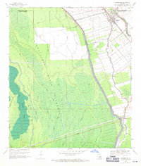
1969 Map of Maringouin
USGS Topo · Published 1970About this map
Maringouin and the adjacent hamlets of Musson and Ramah occupy the fertile ground along Bayou Grosse Tete, bordered by the massive Atchafalaya Basin Floodway to the west. This landscape is defined by the rigid line of the East Protection Levee, which separates the settled agricultural land and the Texas and Pacific railroad corridor from the wilder wetlands of Des Ourses Swamp and Tight Island. The map records a transition in the local economy, where traditional bayou life meets industrial extraction at the Kenmore Oil and Gas Field and Klondike Oil Field. Genealogy researchers will find significant detail in the placement of several local congregations, including Little Zion Ch, Rising Sun Ch, and Bethany Ch, alongside the St Peter Cem, providing a spatial record of the community's social and religious centers.
Find a feature on this map
34 named features on this map. Tap any name to fly to it.
Don’t see what you’re looking for? This feature index may not catch every label — zoom into the map to look around manually.
Map Details
Editions of this 1969 Maringouin Map
2 editions found
Other maps of this area

1906 · Bayou Sara
USGS Topo · 1:125,000

1935 · Osca Bayou
USGS Topo · 1:62,500

1939 · Fordoche
USGS Topo · 1:62,500

1940 · Grosse Tete
USGS Topo · 1:62,500

1953 · Cow Bayou
USGS Topo · 1:24,000

1953 · Maringouin
USGS Topo · 1:24,000

1953 · Grosse Tete SW
USGS Topo · 1:24,000

1954 · Fordoche
USGS Topo · 1:24,000

1954 · Erwinville
USGS Topo · 1:24,000

1954 · Grosse Tete
USGS Topo · 1:24,000