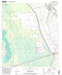
1999 Map of Maringouin
USGS Topo · Published 2001About this map
Bayou Grosse Tete and Bayou Maringouin define the agricultural and transport corridor of this corner of the Louisiana delta at the end of the 20th century. The settlement of Maringouin serves as a focal point along the Union Pacific rail line, where traditional parish life is evidenced by numerous local landmarks like St Peter Cem and Rising Star Ch. East of the massive Atchafalaya Basin Protection Levee, the landscape is partitioned into long, narrow river lots, a legacy of French colonial land patterns.
Find a feature on this map
43 named features on this map. Tap any name to fly to it.
Don’t see what you’re looking for? This feature index may not catch every label — zoom into the map to look around manually.
Map Details
Editions of this 1999 Maringouin Map
2 editions found
Other maps of this area

1906 · Bayou Sara
USGS Topo · 1:125,000

1935 · Osca Bayou
USGS Topo · 1:62,500

1939 · Fordoche
USGS Topo · 1:62,500

1940 · Grosse Tete
USGS Topo · 1:62,500

1953 · Cow Bayou
USGS Topo · 1:24,000

1953 · Maringouin
USGS Topo · 1:24,000

1953 · Grosse Tete SW
USGS Topo · 1:24,000

1954 · Fordoche
USGS Topo · 1:24,000

1954 · Erwinville
USGS Topo · 1:24,000

1954 · Grosse Tete
USGS Topo · 1:24,000