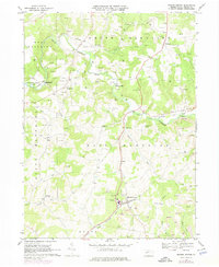
1968 Map of Marion Center
USGS Topo · Published 1974About this map
Marion Center serves as a primary hub in this portion of Indiana County, situated at the intersection of a developing road network and the Baltimore and Ohio railroad line. The landscape is defined by the winding course of Little Mahoning Creek, which carves through the townships of North, South, East, and West Mahoning. This 1968 snapshot captures a rural economy in transition, where traditional settlements like Marchand and Georgeville coexist with increasing industrial activity. Numerous strip mines are visible in the eastern and southern sections, particularly along the rail corridors, while an extensive network of gas wells dots the northern hills. Local social life is anchored by several country churches, including Gilgal Ch and Smyrna Ch, and the presence of the Marion Center Speedway north of the main village. The map also records smaller communities such as Mottarns Mill and Oak Tree, providing a detailed look at the region's mid-century rural character.
Find a feature on this map
34 named features on this map. Tap any name to fly to it.
Don’t see what you’re looking for? This feature index may not catch every label — zoom into the map to look around manually.
Map Details
Editions of this 1968 Marion Center Map
4 editions found
Other maps of this area

1902 · Indiana
USGS Topo · 1:62,500

1902 · Barnesboro
USGS Topo · 1:62,500

1904 · Barnesboro
USGS Topo · 1:62,500

1906 · Punxsutawney
USGS Topo · 1:62,500

1909 · Smicksburg
USGS Topo · 1:62,500

1938 · Smicksburg
USGS Topo · 1:62,500

1939 · Smicksburg
USGS Topo · 1:62,500

1939 · Punxsutawney
USGS Topo · 1:62,500

1942 · Punxsutawney
USGS Topo · 1:62,500

1943 · Punxsutawney
USGS Topo · 1:125,000
Featured Places
- Rayne Township, PA
- Barton, East Mahoning Township
- West Mahoning Township, PA
- North Mahoning Township, PA
- East Mahoning Township, PA