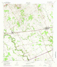
1958 Map of Marion
USGS Topo · Published 1975About this map
The Southern Pacific rail line cuts a straight path through this Texas landscape, connecting the growing settlements of Marion and Cibolo during the late 1950s. The geography is defined by the winding course of Cibolo Creek, which forms a sharp horseshoe at Crescent Bend as it flows toward the south. This survey reveals a transition from traditional agricultural land use to early mid-century developments, evidenced by the presence of the Zuehl Air Force Auxiliary Field in the south and the Schertz Sportsmans Club nearby.
Find a feature on this map
19 named features on this map. Tap any name to fly to it.
Don’t see what you’re looking for? This feature index may not catch every label — zoom into the map to look around manually.
Map Details
Editions of this 1958 Marion Map
2 editions found
Other maps of this area

1924 · New Braunfels No 4
USGS Topo · 1:48,000

1925 · New Braunfels No 1
USGS Topo · 1:48,000

1927 · New Braunfels
USGS Topo · 1:62,500

1953 · Schertz
USGS Topo · 1:24,000

1953 · Bat Cave
USGS Topo · 1:24,000

1953 · Martinez
USGS Topo · 1:24,000

1954 · San Antonio
USGS Topo · 1:250,000

1957 · San Antonio
USGS Topo · 1:250,000

1957 · New Berlin
USGS Topo · 1:24,000

1958 · Marion
USGS Topo · 1:24,000