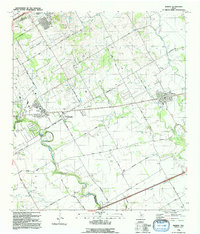
1992 Map of Marion
USGS Topo · Published 1992About this map
The winding course of Cibolo Creek anchors this landscape in eastern Guadalupe County, creating the distinctive Crescent Bend near the border of Bexar County. In the early 1990s, the corridor between Cibolo and Marion reveals a transition from suburban expansion near Schertz to a more agricultural landscape dominated by farm-to-market roads and the Southern Pacific rail line. The small settlement of Haeckerville sits centrally along the network of local routes like Schaefer Road and Youngsford Road, which connect scattered homesteads and local landmarks such as St Paul Church. To the south, the topography descends toward Womans Hollow and Santa Clara Creek, where the land is marked by resource extraction at various Gravel Pits and the quiet presence of local burial grounds like Slappers Cem.
Find a feature on this map
41 named features on this map. Tap any name to fly to it.
Don’t see what you’re looking for? This feature index may not catch every label — zoom into the map to look around manually.
Map Details
Editions of this 1992 Marion Map
2 editions found
Other maps of this area

1924 · New Braunfels No 4
USGS Topo · 1:48,000

1925 · New Braunfels No 1
USGS Topo · 1:48,000

1927 · New Braunfels
USGS Topo · 1:62,500

1953 · Schertz
USGS Topo · 1:24,000

1953 · Bat Cave
USGS Topo · 1:24,000

1953 · Martinez
USGS Topo · 1:24,000

1954 · San Antonio
USGS Topo · 1:250,000

1957 · San Antonio
USGS Topo · 1:250,000

1957 · New Berlin
USGS Topo · 1:24,000

1958 · Marion
USGS Topo · 1:24,000