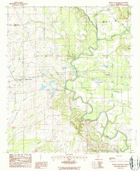
1987 Map of Marion Junction
USGS Topo · Published 1987About this map
Marion Junction stands as a significant rural rail node where the landscape of western Dallas County meets the Cahaba River valley. The map documents a period of transition in the late twentieth century, showing the established settlement at the junction alongside nearby Harrell and the expansive Camp Selma grounds. The river's winding course dominates the eastern half of the quadrangle, flanked by numerous tributaries like Oakmulgee Creek and Possum Creek. Local industry and infrastructure are noted through features such as a Gravel Pit and a Gaging Station on the river. Water remains a central theme for the area, with Lake Lanier and Sherman Pond providing local landmarks amidst the network of branches and creeks that feed into the Cahaba's primary channel.
Find a feature on this map
19 named features on this map. Tap any name to fly to it.
Don’t see what you’re looking for? This feature index may not catch every label — zoom into the map to look around manually.
Map Details
Editions of this 1987 Marion Junction Map
This is the sole edition of this map. No revisions or reprints were ever made.
Other maps of this area

1953 · Montgomery
USGS Topo · 1:250,000

1956 · Montgomery
USGS Topo · 1:250,000

1957 · Montgomery
USGS Topo · 1:250,000

1958 · Selma
USGS Topo · 1:62,500

1958 · Selma
USGS Topo · 1:24,000

1959 · Summerfield
USGS Topo · 1:62,500

1968 · Browns
USGS Topo · 1:24,000

1968 · Safford
USGS Topo · 1:24,000

1975 · Selma NW
USGS Topo · 1:24,000

1975 · Summerfield SW
USGS Topo · 1:24,000