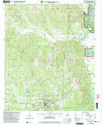
2002 Map of Marion North
USGS Topo · Published 2004About this map
The city of Marion serves as the focal point of this survey, anchored by the campus of Judson College and the sprawling Marion National Fish Hatchery. The landscape transition reflects the diverse land use of Perry County, from the academic and civic center of the town to the managed wilderness of the Talladega National Forest in the northeast. Waterways such as Old Town Creek and the Cahaba River define the local topography, while numerous rural congregations like Simpson Chapel and Mt Zion Ch suggest a landscape structured by tight-knit community nodes. Genealogists will find particular value in the documentation of family and community burial grounds, including the Mt Nebo Cem and Heard Cem, which sit alongside distinctive landmarks like the Marion Lookout and various Communication Towers.
Find a feature on this map
30 named features on this map. Tap any name to fly to it.
Don’t see what you’re looking for? This feature index may not catch every label — zoom into the map to look around manually.
Map Details
Editions of this 2002 Marion North Map
This is the sole edition of this map. No revisions or reprints were ever made.
Other maps of this area

1953 · Montgomery
USGS Topo · 1:250,000

1956 · Montgomery
USGS Topo · 1:250,000

1957 · Montgomery
USGS Topo · 1:250,000

1959 · Summerfield
USGS Topo · 1:62,500

1975 · Summerfield SW
USGS Topo · 1:24,000

1979 · Marion North
USGS Topo · 1:24,000

1979 · Scott Station
USGS Topo · 1:24,000

1979 · Morgan Springs
USGS Topo · 1:24,000

1979 · Marion South
USGS Topo · 1:24,000

1979 · Harrisburg
USGS Topo · 1:24,000