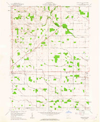
1961 Map of Mark Center
USGS Topo · Published 1962About this map
The Baltimore and Ohio railroad corridor anchors this 1961 survey, cutting a straight line through the agricultural heart of northwestern Ohio. Small rural hubs such as Mark Center and Hicksville serve as the primary points of activity, with the Township High Sch standing as a central landmark for the surrounding farming community. The landscape is defined by a dense network of watercourses, including the North Fork, Middle Fork, and South Fork, which meander through the townships of Milford, Farmer, and Hicksville.
Find a feature on this map
40 named features on this map. Tap any name to fly to it.
Don’t see what you’re looking for? This feature index may not catch every label — zoom into the map to look around manually.
Map Details
Editions of this 1961 Mark Center Map
2 editions found
Other maps of this area

1914 · Bryan
USGS Topo · 1:62,500

1914 · Paulding
USGS Topo · 1:62,500

1943 · Bryan
USGS Topo · 1:62,500

1944 · Paulding
USGS Topo · 1:62,500

1953 · Fort Wayne
USGS Topo · 1:250,000

1956 · Fort Wayne
USGS Topo · 1:250,000

1958 · Hicksville
USGS Topo · 1:24,000

1958 · Woodburn North
USGS Topo · 1:24,000

1958 · Butler East
USGS Topo · 1:24,000

1960 · Sherwood
USGS Topo · 1:24,000