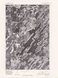
1976 Map of Markham SW
USGS Topo · Published 1979About this map
The Whiteface Reservoir dominates this 1970s orthophotoquad, showing the intricate, island-rich shoreline of this man-made basin in northern Minnesota. Captured during a May 1976 aerial survey, the imagery reveals the sparsely settled landscape around the community of Markham. The terrain is characterized by the complex drainage patterns of the Whiteface River as it enters and exits the reservoir, surrounded by dense forest cover and wetlands. To the east, Linwood Lake appears as a distinct body of water separated from the main reservoir system. This map provides a precise photographic record of the region’s timber and water resources before further shoreline development or forest succession altered the visible landscape of St. Louis County.
Find a feature on this map
4 named features on this map. Tap any name to fly to it.
Don’t see what you’re looking for? This feature index may not catch every label — zoom into the map to look around manually.
Map Details
Editions of this 1976 Markham SW Map
This is the sole edition of this map. No revisions or reprints were ever made.
Other maps of this area

1951 · Palo
USGS Topo · 1:24,000

1951 · Makinen
USGS Topo · 1:24,000

1954 · Hibbing
USGS Topo · 1:250,000

1956 · Whiteface
USGS Topo · 1:24,000

1957 · Hibbing
USGS Topo · 1:250,000

1957 · Markham
USGS Topo · 1:62,500

1957 · Comstock Lake
USGS Topo · 1:24,000
1957 · Boulder Lake Reservoir NE
USGS Topo · 1:24,000

1958 · Hibbing
USGS Topo · 1:250,000

1964 · Hibbing
USGS Topo · 1:250,000