
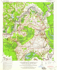
1940 Map of Marksville
USGS Topo · Published 1943About this map
Marksville and the surrounding river bottomlands of Avoyelles Parish are documented here during a period of significant flood control activity managed by the Corps of Engineers. The Red River dominates the northern landscape, its shifting course marked by historical boundaries like the Meander Line 1844. The interaction between the elevated terrain of the Avoyelles Prairie and the complex drainage of Bayou des Glaises and Bayou du Lac highlights the area's agricultural and hydrologic history.
Find a feature on this map
97 named features on this map. Tap any name to fly to it.
Don’t see what you’re looking for? This feature index may not catch every label — zoom into the map to look around manually.
Map Details
Editions of this 1940 Marksville Map
2 editions found
Other maps of this area

1935 · Turkey Creek
USGS Topo · 1:62,500

1935 · Tooleys
USGS Topo · 1:62,500

1935 · Lecompte
USGS Topo · 1:62,500

1941 · Voorhies
USGS Topo · 1:62,500

1941 · Alexandria
USGS Topo · 1:62,500

1941 · Buckeye
USGS Topo · 1:62,500

1941 · Tooleys
USGS Topo · 1:62,500

1948 · Bunkie
USGS Topo · 1:62,500

1949 · Turkey Creek
USGS Topo · 1:62,500

1952 · Lake Charles
USGS Topo · 1:250,000