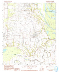
1982 Map of Marksville South
USGS Topo · Published 1993About this map
Avoyelles Parish's intricate water network defines this landscape, where the meandering Bayou des Glaises and La Vieille Riviere cut through the low-lying terrain. The transition from the settled areas of Marksville and Mansura into the wetlands of the Spring Bayou State Wildlife Management Area is clearly marked by the shift from grid-like agricultural tracts to the organic shapes of Lac aux Perles and Lac Spring Bayou. For those researching family history, several significant landmarks are noted, including St Joseph Cem, St Pauls Ch, and the Jerusalem Cem. The map documents the early 1980s infrastructure of central Louisiana, from the Marksville Municipal Airport to the small communities of Hessmer and Cottonport, providing a look at the rural landscape before modern development altered these historic corridors.
Find a feature on this map
35 named features on this map. Tap any name to fly to it.
Don’t see what you’re looking for? This feature index may not catch every label — zoom into the map to look around manually.
Map Details
Editions of this 1982 Marksville South Map
2 editions found
Other maps of this area

1940 · Marksville
USGS Topo · 1:62,500

1941 · Voorhies
USGS Topo · 1:62,500

1948 · Bunkie
USGS Topo · 1:62,500

1952 · Lake Charles
USGS Topo · 1:250,000

1953 · Alexandria
USGS Topo · 1:250,000

1953 · Natchez
USGS Topo · 1:250,000

1954 · Lake Charles
USGS Topo · 1:250,000

1954 · Baton Rouge
USGS Topo · 1:250,000

1955 · Odenburg
USGS Topo · 1:62,500

1955 · Alexandria
USGS Topo · 1:250,000