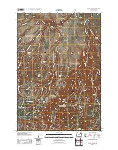
2011 Map of Marley Creek
USGS Topo · Published 2011About this map
Starkey and the nearby Camp Elkanah anchor this high-elevation landscape in Union County, where the terrain is defined by the winding course of the Grande Ronde River and its numerous tributaries. The map details a complex network of forest access roads, such as Starkey Rd and Mt Emily-Camp Rd, which navigate the steep topography of Tybow Canyon and Fly Ridge. These routes highlight the area's importance for timber management and backcountry recreation.
Find a feature on this map
32 named features on this map. Tap any name to fly to it.
Don’t see what you’re looking for? This feature index may not catch every label — zoom into the map to look around manually.
Map Details
Editions of this 2011 Marley Creek Map
This is the sole edition of this map. No revisions or reprints were ever made.
Other maps of this area

1953 · Pendleton
USGS Topo · 1:250,000

1956 · Pendleton
USGS Topo · 1:250,000

1964 · Mc Intyre Creek
USGS Topo · 1:24,000

1964 · Kamela SE
USGS Topo · 1:24,000

1965 · Limber Jim Creek
USGS Topo · 1:24,000

1965 · Marley Creek
USGS Topo · 1:24,000

1965 · Little Beaver Creek
USGS Topo · 1:24,000

1965 · Fly Valley
USGS Topo · 1:24,000

1967 · Tower Mtn
USGS Topo · 1:24,000

1967 · Sullivan Gulch
USGS Topo · 1:24,000