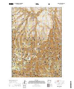
2020 Map of Marley Creek
USGS Topo · Published 2020About this map
Starkey and Camp Elkanah serve as central points for this high-elevation landscape within the Whitman National Forest. The Grande Ronde River flows through the northeastern corner, joined by tributaries like Meadow Cr and Marley Creek. This area of Union County is defined by its numerous water sources, including Blue Mountain Spring, Coon Spring, and Section Line Spring, which historically supported local grazing and forestry activities. Genealogy researchers may find interest in the Starkey Cem located near the northern border. The terrain is marked by significant topographical landmarks such as Whitehorse Ridge, Fly Ridge, and the prominent Johnson Rock to the south. Transport through these wooded gulches and ridges is facilitated by a network of forest routes, including Fly Creek Rd and Starkey Rd, which connect the small settlements to the deeper wilderness.
Find a feature on this map
41 named features on this map. Tap any name to fly to it.
Don’t see what you’re looking for? This feature index may not catch every label — zoom into the map to look around manually.
Map Details
Editions of this 2020 Marley Creek Map
This is the sole edition of this map. No revisions or reprints were ever made.
Other maps of this area

1953 · Pendleton
USGS Topo · 1:250,000

1956 · Pendleton
USGS Topo · 1:250,000

1964 · Mc Intyre Creek
USGS Topo · 1:24,000

1964 · Kamela SE
USGS Topo · 1:24,000

1965 · Limber Jim Creek
USGS Topo · 1:24,000

1965 · Marley Creek
USGS Topo · 1:24,000

1965 · Little Beaver Creek
USGS Topo · 1:24,000

1965 · Fly Valley
USGS Topo · 1:24,000

1967 · Tower Mtn
USGS Topo · 1:24,000

1967 · Sullivan Gulch
USGS Topo · 1:24,000