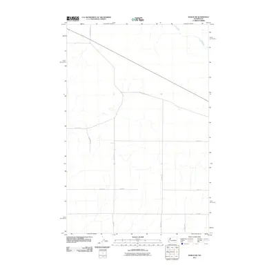
2011 Map of Marlin SW
USGS Topo · Published 2011About this map
Crab Creek meanders through the northeast corner of this Grant County landscape, providing the primary hydrological relief for an area dominated by an orderly grid of agricultural roads. The transition of the region's transportation network is evident in the path of Old Highway 10 Rd E, which cuts diagonally across the northern section, contrasting with the strictly north-south and east-west alignments of later infrastructure like Lessor Rd N and Kissler Rd E. This 2011 survey, produced by the U.S. Geological Survey, illustrates the systematic organization of the Columbia Basin, where family-named routes such as N Graedel Rd, Moody Rd N, and N Johnson Rd define the boundaries of modern rural property and land use.
Find a feature on this map
14 named features on this map. Tap any name to fly to it.
Don’t see what you’re looking for? This feature index may not catch every label — zoom into the map to look around manually.
Map Details
Editions of this 2011 Marlin SW Map
This is the sole edition of this map. No revisions or reprints were ever made.
Other maps of this area

1923 · Wheeler
USGS Topo · 1:62,500

1925 · Wheeler
USGS Topo · 1:62,500

1925 · Schrag
USGS Topo · 1:62,500

1953 · Ritzville
USGS Topo · 1:250,000

1956 · Wheeler NE
USGS Topo · 1:24,000

1956 · Wilson Creek SE
USGS Topo · 1:24,000

1956 · Wilson Creek
USGS Topo · 1:62,500
1956 · Wheeler
USGS Topo · 1:62,500

1959 · Ritzville
USGS Topo · 1:250,000

1965 · Ritzville
USGS Topo · 1:250,000