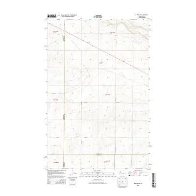
2013 Map of Marlin SW
USGS Topo · Published 2013About this map
Crab Cr cuts through the northeastern corner of this landscape, marking the primary drainage in an area defined by dry coulees and a grid-based road system. This territory, where Grant, Lincoln, and Adams counties meet, shows the precise organization of the Public Land Survey System with section lines deeply ingrained into the local infrastructure. Black Rock Coulee runs through the central portion of the map, illustrating the unique geological formations typical of the Channeled Scablands. The network of section-line roads, including Kissler Rd E, N Graedel Rd, and Bates Rd E, provides clear access for studying 21st-century land use and property boundaries. The primary artery, Wa-28, diagonally traverses the northern sections, connecting this rural expanse to the larger regional transport web.
Find a feature on this map
26 named features on this map. Tap any name to fly to it.
Don’t see what you’re looking for? This feature index may not catch every label — zoom into the map to look around manually.
Map Details
Editions of this 2013 Marlin SW Map
This is the sole edition of this map. No revisions or reprints were ever made.
Other maps of this area

1923 · Wheeler
USGS Topo · 1:62,500

1925 · Wheeler
USGS Topo · 1:62,500

1925 · Schrag
USGS Topo · 1:62,500

1953 · Ritzville
USGS Topo · 1:250,000

1956 · Wheeler NE
USGS Topo · 1:24,000

1956 · Wilson Creek SE
USGS Topo · 1:24,000

1956 · Wilson Creek
USGS Topo · 1:62,500
1956 · Wheeler
USGS Topo · 1:62,500

1959 · Ritzville
USGS Topo · 1:250,000

1965 · Ritzville
USGS Topo · 1:250,000