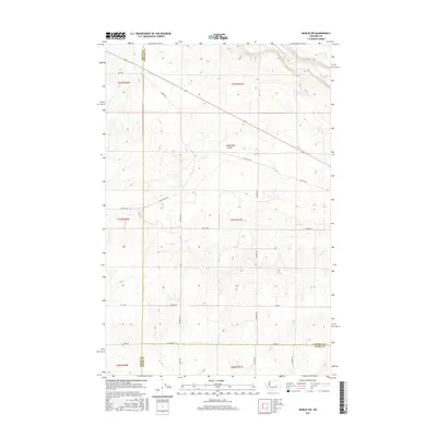
2017 Map of Marlin SW
USGS Topo · Published 2017About this map
Black Rock Coulee cuts through the high desert of eastern Washington, marking a landscape defined by dramatic geological formations and a network of rural section lines. This 2017 survey shows the intersection of Grant, Lincoln, and Adams counties, where the sparse drainage of Crab Cr winds through the northern reaches of the quadrangle. The map documents a strictly rectilinear settlement pattern, where family names are etched into the infrastructure via thoroughfares like Kissler Rd, Graedel Rd, and Lesser Rd N. Significant for its depiction of modern transit following historical routes, the Old Hwy Lp transects the terrain, providing a look at how early 20th-century automotive paths were integrated into the contemporary local road system alongside newer connectors such as Bates Rd E and Black Rock Rd.
Find a feature on this map
27 named features on this map. Tap any name to fly to it.
Don’t see what you’re looking for? This feature index may not catch every label — zoom into the map to look around manually.
Map Details
Editions of this 2017 Marlin SW Map
This is the sole edition of this map. No revisions or reprints were ever made.
Other maps of this area

1923 · Wheeler
USGS Topo · 1:62,500

1925 · Wheeler
USGS Topo · 1:62,500

1925 · Schrag
USGS Topo · 1:62,500

1953 · Ritzville
USGS Topo · 1:250,000

1956 · Wheeler NE
USGS Topo · 1:24,000

1956 · Wilson Creek SE
USGS Topo · 1:24,000

1956 · Wilson Creek
USGS Topo · 1:62,500
1956 · Wheeler
USGS Topo · 1:62,500

1959 · Ritzville
USGS Topo · 1:250,000

1965 · Ritzville
USGS Topo · 1:250,000