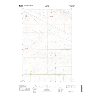
2020 Map of Marlin SW
USGS Topo · Published 2020About this map
Black Rock Coulee defines the drainage and topography of this landscape in eastern Washington, where the high desert meets the structured agricultural grid. This 2020 record reflects a modern rural environment where historic travel routes like Old Hwy Lp and Black Rock Rd intersect with a sparse network of county roads. The map illustrates the convergence of three counties—Grant, Lincoln, and Adams—marking a significant jurisdictional boundary point just north of W Davis Rd. The land is meticulously partitioned by the Public Land Survey System into townships and sections, including t21n r31e and t20n r31e, showcasing a legacy of land division that has shaped the region's farming and ranching identity. Researchers will find a highly detailed view of the local road system, from Graedel Rd to Kissler Rd, providing a clear look at the infrastructure supporting this remote part of the Columbia Basin.
Find a feature on this map
25 named features on this map. Tap any name to fly to it.
Don’t see what you’re looking for? This feature index may not catch every label — zoom into the map to look around manually.
Map Details
Editions of this 2020 Marlin SW Map
This is the sole edition of this map. No revisions or reprints were ever made.
Other maps of this area

1923 · Wheeler
USGS Topo · 1:62,500

1925 · Wheeler
USGS Topo · 1:62,500

1925 · Schrag
USGS Topo · 1:62,500

1953 · Ritzville
USGS Topo · 1:250,000

1956 · Wheeler NE
USGS Topo · 1:24,000

1956 · Wilson Creek SE
USGS Topo · 1:24,000

1956 · Wilson Creek
USGS Topo · 1:62,500
1956 · Wheeler
USGS Topo · 1:62,500

1959 · Ritzville
USGS Topo · 1:250,000

1965 · Ritzville
USGS Topo · 1:250,000