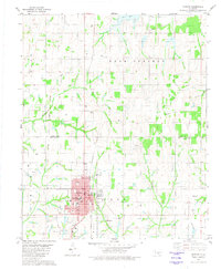
1981 Map of Marlow
USGS Topo · Published 1981About this map
Marlow serves as the focal point of this 1980s-era study, revealing a dense grid of streets such as Main Ave and Cheyenne Ave alongside essential town infrastructure like the Armory, Power Plant, and the Middle School. The surrounding Stephens County countryside is heavily marked by the energy industry, with numerous Oil Wells and a defined Oil Field scattered across the landscape near Stone Park.
Find a feature on this map
33 named features on this map. Tap any name to fly to it.
Don’t see what you’re looking for? This feature index may not catch every label — zoom into the map to look around manually.
Map Details
Editions of this 1981 Marlow Map
This is the sole edition of this map. No revisions or reprints were ever made.
Other maps of this area

1902 · Rush Springs
USGS Topo · 1:125,000

1949 · Cement
USGS Topo · 1:62,500

1949 · Nellie
USGS Topo · 1:62,500

1949 · Rush Springs
USGS Topo · 1:62,500

1950 · Rush Springs
USGS Topo · 1:62,500

1950 · Marlow
USGS Topo · 1:62,500

1951 · Marlow
USGS Topo · 1:62,500

1955 · Lawton
USGS Topo · 1:250,000
1956 · Rocky Ford
USGS Topo · 1:24,000
1956 · Denton
USGS Topo · 1:24,000