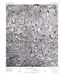
1975 Map of Marlow NW
USGS Topo · Published 1976About this map
Marlow serves as the focal point of this 1975 orthophotoquad, showing the town's residential grid and infrastructure as it existed in the mid-1970s. The aerial imagery provides a direct look at the agricultural patterns of Grady County, where contoured fields and terraced lands dominate the rural landscape. Wildhorse Creek and its various tributaries wind through the terrain, illustrating the natural drainage patterns that have historically shaped local land use. This specific type of survey, an orthophotoquad, offers researchers a precise visual record of field boundaries, road networks, and homestead locations that traditional line-drawn maps often simplify. It is a vital resource for understanding the physical state of the region's farms and the southern outskirts of the primary settlement during this era.
Find a feature on this map
2 named features on this map. Tap any name to fly to it.
Don’t see what you’re looking for? This feature index may not catch every label — zoom into the map to look around manually.
Map Details
Editions of this 1975 Marlow NW Map
This is the sole edition of this map. No revisions or reprints were ever made.
Other maps of this area

1902 · Rush Springs
USGS Topo · 1:125,000

1949 · Cement
USGS Topo · 1:62,500

1949 · Nellie
USGS Topo · 1:62,500

1949 · Rush Springs
USGS Topo · 1:62,500

1950 · Rush Springs
USGS Topo · 1:62,500

1950 · Marlow
USGS Topo · 1:62,500

1951 · Marlow
USGS Topo · 1:62,500

1955 · Lawton
USGS Topo · 1:250,000
1956 · Rocky Ford
USGS Topo · 1:24,000
1956 · Denton
USGS Topo · 1:24,000