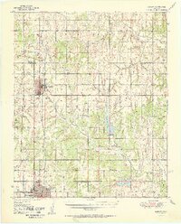
1951 Map of Marlow
USGS Topo · Published 1951About this map
The Chicago Rock Island and Pacific railroad forms a rigid north-south axis through this Oklahoma landscape, connecting the growing hubs of Marlow and Duncan. This post-war survey illustrates a rural society transitioning from traditional trail routes to mid-century modernization. The legendary Chisholm Trail is documented here as both a terrain feature and a roadway, winding past Lake Duncan and the Union Center Ch.
Find a feature on this map
49 named features on this map. Tap any name to fly to it.
Don’t see what you’re looking for? This feature index may not catch every label — zoom into the map to look around manually.
Map Details
Editions of this 1951 Marlow Map
2 editions found
Other maps of this area

1901 · Addington
USGS Topo · 1:125,000

1902 · Rush Springs
USGS Topo · 1:125,000

1949 · Cement
USGS Topo · 1:62,500

1949 · Nellie
USGS Topo · 1:62,500

1949 · Rush Springs
USGS Topo · 1:62,500

1950 · Rush Springs
USGS Topo · 1:62,500

1950 · Marlow
USGS Topo · 1:62,500

1951 · Marlow
USGS Topo · 1:62,500

1955 · Lawton
USGS Topo · 1:250,000
1956 · Rocky Ford
USGS Topo · 1:24,000