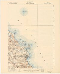
1907 Map of Marquette
USGS Topo · Published 1931About this map
The industrial and maritime character of Marquette is clearly defined in this early twentieth-century survey, where the city’s harbor infrastructure meets the iron-rich landscape of the Upper Peninsula. Major transportation arteries like the Duluth South Shore and Atlantic and the Marquette and Southeastern railroads converge near the Harbor Basin, illustrating the town's role as a vital shipping hub. Beyond the urban grid, the map documents specialized facilities such as the State Prison on Marquette Bay and the Powder Works north of the Dead River. Natural landmarks including Sugarloaf Mtn and Hogback Mtn tower over the coastline, while Presque Isle serves as a prominent geographic anchor. Smaller settlements like Forestville, Bancroft, and Bagdad appear along the rail lines, providing a detailed view of local settlement patterns before further twentieth-century expansion.
Find a feature on this map
35 named features on this map. Tap any name to fly to it.
Don’t see what you’re looking for? This feature index may not catch every label — zoom into the map to look around manually.
Map Details
Editions of this 1907 Marquette Map
3 editions found
Other maps of this area

1907 · Marquette
USGS Topo · 1:62,500

1932 · Harvey NW
USGS Topo · 1:31,680

1932 · Harvey NE
USGS Topo · 1:31,680

1950 · Skandia NW
USGS Topo · 1:31,680

1952 · Sands
USGS Topo · 1:24,000

1952 · Ishpeming
USGS Topo · 1:62,500

1952 · Gwinn
USGS Topo · 1:62,500

1952 · Palmer
USGS Topo · 1:24,000

1953 · Marquette NW
USGS Topo · 1:24,000

1953 · Negaunee
USGS Topo · 1:24,000
Featured Places
- Marquette, MI
- Trowbridge Park, MI
- Negaunee Township, MI
- Brookton Corners, Marquette
- Marquette Township, MI