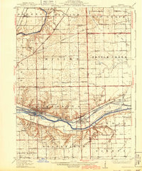
1916 Map of Marseilles
USGS Topo · Published 1943About this map
Marseilles serves as the industrial and transportation anchor of this landscape, situated where the Illinois River meets a complex network of rail and canal infrastructure. The presence of the Michigan Canal running parallel to the river, alongside the Chicago Rock Island and Pacific RR, highlights the critical role of mid-twentieth-century freight corridors. Significant early 20th-century history is preserved here, including the Chicago Ottawa and Peoria Electric RR, which is already noted as abandoned by this printing.
Find a feature on this map
85 named features on this map. Tap any name to fly to it.
Don’t see what you’re looking for? This feature index may not catch every label — zoom into the map to look around manually.
Map Details
Editions of this 1916 Marseilles Map
4 editions found
Other maps of this area

1892 · Morris
USGS Topo · 1:62,500

1892 · Marseilles
USGS Topo · 1:62,500

1892 · Ottawa
USGS Topo · 1:62,500

1915 · Ottawa
USGS Topo · 1:62,500

1916 · Marseilles
USGS Topo · 1:62,500

1918 · Morris
USGS Topo · 1:62,500

1925 · Yorkville
USGS Topo · 1:62,500

1925 · Streator
USGS Topo · 1:62,500

1927 · Streator
USGS Topo · 1:62,500

1940 · Marseilles
USGS Topo · 1:62,500