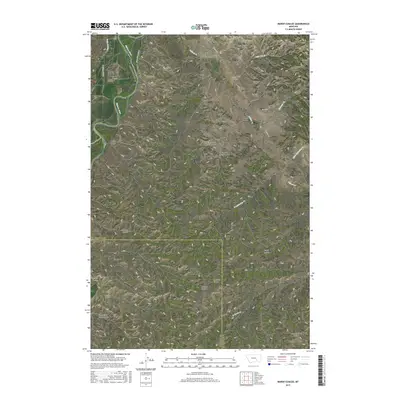
2017 Map of Marsh Coulee
USGS Topo · Published 2017About this map
The Bighorn River cuts through the northwestern corner of this landscape, defining a fertile valley where the Victory Ditch and Big Ox Bottom sit adjacent to Big Horn Valley Rd. This section of the Crow Indian Reservation is characterized by a dense network of coulees and intermittent creeks that drain toward the river. To the south, the Mission Bottom and Mission Coulee offer evidence of historical land use near the water's edge, while the interior is marked by numerous family-named topographical features such as Joe Black Coulee, Eckman Coulee, and West Bosshart Coulee. The terrain rises toward the east, where Tullock Cr and its tributaries, including Thunder Cr and Little Joe Cr, carve through the high ground. Notable for local history, the map includes intriguing local names like the Fountain of Youth Coulee, illustrating the distinctive nomenclature used by early ranchers and settlers in this part of Montana.
Find a feature on this map
32 named features on this map. Tap any name to fly to it.
Don’t see what you’re looking for? This feature index may not catch every label — zoom into the map to look around manually.
Map Details
Editions of this 2017 Marsh Coulee Map
This is the sole edition of this map. No revisions or reprints were ever made.
Other maps of this area

1894 · Fort Custer
USGS Topo · 1:125,000

1954 · Hardin
USGS Topo · 1:250,000

1954 · Forsyth
USGS Topo · 1:250,000

1957 · Hardin
USGS Topo · 1:250,000

1957 · Forsyth
USGS Topo · 1:250,000

1958 · Forsyth
USGS Topo · 1:250,000

1958 · Hardin
USGS Topo · 1:250,000

1960 · Bighorn
USGS Topo · 1:24,000

1960 · Foster
USGS Topo · 1:24,000

1960 · Custer
USGS Topo · 1:24,000