
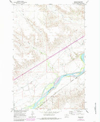
1967 Map of Marsh
USGS Topo · Published 1970About this map
The Yellowstone River cuts through this portion of Dawson County, Montana, defining a landscape shaped by both natural drainage and early 20th-century irrigation efforts. The small settlement of Marsh serves as a local hub near the Northern Pacific railroad line, which follows the river's southern bank. This survey documents the complex water management systems of the era, including the Main Canal, which parallels the river to support agriculture in the bottomlands. Education and community life are represented by the Yale Sch and a local Cem, reflecting the rural social structure of the late 1960s. The historical importance of the corridor is further noted by the Lewis and Clark Trail, which crosses the northern terrain above the winding paths of Cracker Box Creek and Clear Creek.
Find a feature on this map
15 named features on this map. Tap any name to fly to it.
Don’t see what you’re looking for? This feature index may not catch every label — zoom into the map to look around manually.
Map Details
Editions of this 1967 Marsh Map
2 editions found
Other maps of this area

1909 · Glendive
USGS Topo · 1:250,000

1953 · Miles City
USGS Topo · 1:250,000

1954 · Glendive
USGS Topo · 1:250,000

1957 · Miles City
USGS Topo · 1:250,000

1957 · Glendive
USGS Topo · 1:250,000

1958 · Miles City
USGS Topo · 1:250,000

1958 · Glendive
USGS Topo · 1:250,000

1966 · Fallon
USGS Topo · 1:24,000

1966 · Marsh SW
USGS Topo · 1:24,000

1967 · Hoyt
USGS Topo · 1:24,000