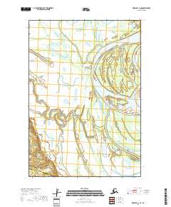
2018 Map of Marshall C-1 SE
USGS Topo · Published 2018About this map
Devils Elbow and the meandering channels of the Reindeer River dominate this aquatic landscape along the border of the Kusilvak Census Area and the Bethel Census Area. The 2018 survey reveals a terrain defined by shifting watercourses and seasonal wetlands, where landforms like Bluefish Island are shaped by the surrounding Middle Slough. This environment reflects the dynamic nature of the Alaskan delta system, where small changes in elevation dictate the flow of major waterways and the seasonal accessibility of the back country. The lack of permanent structures and roads on this map underscores the isolation and the preservation of traditional landscape patterns in this northern region, providing an essential record of the natural hydrology and land divisions within the Public Land Survey System.
Find a feature on this map
11 named features on this map. Tap any name to fly to it.
Don’t see what you’re looking for? This feature index may not catch every label — zoom into the map to look around manually.
Map Details
Editions of this 2018 Marshall C-1 SE Map
This is the sole edition of this map. No revisions or reprints were ever made.
Other maps of this area

1947 · Russian Mission
USGS Topo · 1:250,000

1950 · Russian Mission
USGS Topo · 1:250,000

1951 · Marshall
USGS Topo · 1:250,000

1952 · Russian Mission C-8
USGS Topo · 1:63,360

1952 · Russian Mission B-8
USGS Topo · 1:63,360

1952 · Marshall C-1
USGS Topo · 1:63,360
1954 · Marshall B-1
USGS Topo · 1:63,360

1954 · Marshall
USGS Topo · 1:250,000

1980 · Russian Mission
USGS Topo · 1:250,000
2017 · Russian Mission C-8 NW
USGS Topo · 1:25,000