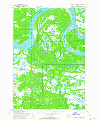
1952 Map of Marshall D-2
USGS Topo · Published 1964About this map
Yukon River hydraulics dominate this early 1950s landscape, where the shifting river creates a complex network of braids and secondary channels. The prominent Dogtooth Bend marks a sharp transition in the main watercourse, while the Poltes Slough and Center Slough delineate the low-lying interior islands and marshy flats. These waterways provided the primary infrastructure for movement in the region, supplemented only by seasonal routes like the Winter Trail that cuts across the northern reaches. Settlement is sparse, represented by a lone Cabin along the bank, indicating a landscape utilized for seasonal trapping, fishing, or transit rather than permanent township development. The map also traces the winding path of the Reindeer River through the southern wetlands, illustrating the intricate drainage patterns characteristic of the Alaskan wilderness before significant modern alteration.
Find a feature on this map
14 named features on this map. Tap any name to fly to it.
Don’t see what you’re looking for? This feature index may not catch every label — zoom into the map to look around manually.
Map Details
Editions of this 1952 Marshall D-2 Map
2 editions found
Other maps of this area

1951 · Marshall
USGS Topo · 1:250,000

1952 · Kwiguk
USGS Topo · 1:250,000

1952 · Kwiguk A-2
USGS Topo · 1:63,360

1952 · Kwiguk A-1
USGS Topo · 1:63,360

1952 · Marshall C-1
USGS Topo · 1:63,360
1952 · Marshall D-1
USGS Topo · 1:63,360

1952 · Marshall D-3
USGS Topo · 1:63,360

1954 · Marshall C-3
USGS Topo · 1:63,360
1954 · Marshall C-2
USGS Topo · 1:63,360

1954 · Marshall
USGS Topo · 1:250,000