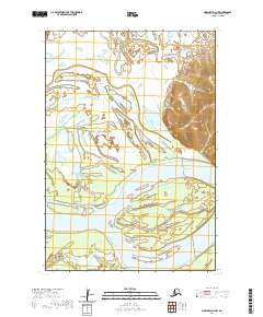
2020 Map of Marshall D-3 NW
USGS Topo · Published 2020About this map
The Yukon River dominates this portion of the Kusilvak region, carving a wide, braided path through the low-lying interior. This 2020 survey illustrates the complex hydrography of the river delta system, where large landforms like Hills Island are defined by secondary channels and slow-moving backwaters. One such waterway, Hills Slough, meanders through the eastern section of the map, creating a network of riparian wetlands and small interconnected lakes typical of this subarctic drainage basin. To the west, East Point stands as a distinct topographical marker along the riverbank. The map provides a precise view of the shifting alluvial landscape, showing how the river's historical movement has shaped the contours of the surrounding terrain and created the numerous unnamed ponds and marshy depressions that dot the area.
Find a feature on this map
8 named features on this map. Tap any name to fly to it.
Don’t see what you’re looking for? This feature index may not catch every label — zoom into the map to look around manually.
Map Details
Editions of this 2020 Marshall D-3 NW Map
This is the sole edition of this map. No revisions or reprints were ever made.
Other maps of this area

1951 · Marshall
USGS Topo · 1:250,000

1952 · Kwiguk
USGS Topo · 1:250,000

1952 · Kwiguk A-2
USGS Topo · 1:63,360

1952 · Kwiguk A-3
USGS Topo · 1:63,360

1952 · Marshall D-4
USGS Topo · 1:63,360

1952 · Marshall D-3
USGS Topo · 1:63,360

1954 · Marshall
USGS Topo · 1:250,000
2018 · Marshall D-3 SE
USGS Topo · 1:25,000
2018 · Marshall D-3 NE
USGS Topo · 1:25,000
2018 · Kwiguk A-2 SW
USGS Topo · 1:25,000