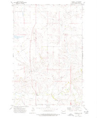
1973 Map of Marshall
USGS Topo · Published 1977About this map
The Knife River meanders through the southern reaches of this Dunn County landscape, providing a vital water source for the settlement of Marshall. This 1972 aerial survey, field-checked in 1973, reveals a rural community centered around the Kyseth Memorial Community Center and the nearby Kyseth Memorial Cemetery. The map documents a rugged drainage system defined by Coyote Creek, Fish Creek, and several unnamed coulees that feed into the primary river valley.
Find a feature on this map
16 named features on this map. Tap any name to fly to it.
Don’t see what you’re looking for? This feature index may not catch every label — zoom into the map to look around manually.
Map Details
Editions of this 1973 Marshall Map
This is the sole edition of this map. No revisions or reprints were ever made.
Other maps of this area

1953 · Watford City
USGS Topo · 1:250,000

1957 · Watford City
USGS Topo · 1:250,000

1967 · Watford City
USGS Topo · 1:250,000

1973 · Marshall SE
USGS Topo · 1:24,000

1973 · Willow Creek West
USGS Topo · 1:24,000

1973 · Schaffner Creek
USGS Topo · 1:24,000

1973 · Marshall SW
USGS Topo · 1:24,000

1973 · Halliday
USGS Topo · 1:24,000

1973 · Dodge
USGS Topo · 1:24,000

1973 · Werner
USGS Topo · 1:24,000