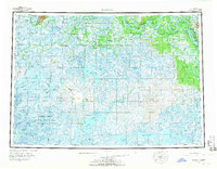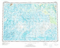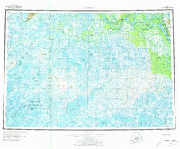
1954 Map of Marshall
USGS Topo · Published 1973About this map
The Yukon River winds through the northern reach of this mid-century survey, serving as the primary corridor for settlements like Pilot Station and Marshall (Fortuna Ledge PO). This region, at the confluence of riverine transport and vast wetlands, is characterized by an intricate network of waterways including Driftwood Slough, East Point Slough, and the Reindeer River. To the south, the landscape is defined by the Clarence Rhode National Wildlife Range Area No 1, a sprawling expanse of lakes and tundra punctuated by the Kusilvak Mountains and Ingakslugwat Hills. Several native settlements and seasonal sites like Owl Village, Utukakarvik, and Chakaktolik are documented across the delta, connected by a Winter Trail that reflects the seasonal nature of travel in the Alaskan interior. The map also records localized landforms such as Dogtooth Bend and The Bluff, which served as vital navigation markers for river traffic.
Find a feature on this map
72 named features on this map. Tap any name to fly to it.
Don’t see what you’re looking for? This feature index may not catch every label — zoom into the map to look around manually.
Map Details
Editions of this 1954 Marshall Map
3 editions found