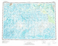
1954 Map of Marshall
USGS Topo · Published 1973About this map
The Yukon River carves a massive arc through the northern section of this interior Alaska landscape, defining a complex network of waterways including Kashunuk Slough and Takshak Slough. Small riverfront outposts like Marshall (Fortuna Ledge PO), Pilot Station, and The Landing serve as the primary hubs for human activity along the banks. Beyond the main channel, a sprawling system of wetlands and lakes, such as Aropuk Lake and Nuigalak Lake, stretches toward the Kusilvak Mountains in the northwest. This 1950s survey shows a land navigated largely by water and seasonal routes, noted by the Winter Trail cutting through the northeast and the designated Clarence Rhode National Wildlife Range covering the southwestern tundra. Traditional sites like Owl Village and Chakaktolik remain anchored to these vital water sources.
Find a feature on this map
61 named features on this map. Tap any name to fly to it.
Don’t see what you’re looking for? This feature index may not catch every label — zoom into the map to look around manually.
Map Details
Editions of this 1954 Marshall Map
3 editions found

Other maps of this area

1947 · Russian Mission
USGS Topo · 1:250,000

1950 · Russian Mission
USGS Topo · 1:250,000

1950 · Bethel
USGS Topo · 1:250,000

1951 · Marshall
USGS Topo · 1:250,000

1951 · Hooper Bay
USGS Topo · 1:250,000

1951 · Nunivak Island
USGS Topo · 1:250,000

1951 · Black
USGS Topo · 1:250,000

1951 · Holy Cross
USGS Topo · 1:250,000

1951 · Baird Inlet
USGS Topo · 1:250,000

1952 · Kwiguk
USGS Topo · 1:250,000