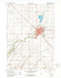
1963 Map of Marshall
USGS Topo · Published 1989About this map
The city of Marshall serves as the focal point of this 1963 survey, appearing as a significant rail and civic hub where the Chicago and North Western and Great Northern railroads intersect. The town's institutional layout is well-defined, featuring the local Courthouse, Central High School, and the Marshall Airport to the west. Industrial and community landmarks are scattered throughout, including a large sewage disposal pond complex to the north and the Fairground near the Redwood River. South of the main city, the small settlement of Lynd sits along the rail line, bordered by numerous gravel pits. The landscape transitions from the urban core of Marshall into the surrounding agricultural townships of Grandview, Fairview, and Lake Marshall, revealing a mid-century prairie landscape managed by an extensive diversion canal system.
Find a feature on this map
32 named features on this map. Tap any name to fly to it.
Don’t see what you’re looking for? This feature index may not catch every label — zoom into the map to look around manually.
Map Details
Editions of this 1963 Marshall Map
3 editions found
Other maps of this area

1953 · New Ulm
USGS Topo · 1:250,000

1957 · New Ulm
USGS Topo · 1:250,000

1958 · New Ulm
USGS Topo · 1:250,000

1962 · Dudley
USGS Topo · 1:24,000

1962 · Cottonwood
USGS Topo · 1:24,000

1962 · Amiret
USGS Topo · 1:24,000

1963 · Russell
USGS Topo · 1:24,000

1963 · Lynd
USGS Topo · 1:24,000

1963 · Marshall SE
USGS Topo · 1:24,000

1963 · Marshall
USGS Topo · 1:24,000