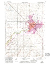
1963 Map of Marshall
USGS Topo · Published 1995About this map
Marshall serves as the regional hub of Lyon County, defined by the winding path of the Redwood River and an intricate network of civil and educational infrastructure. This mid-century survey reveals a growing community, featuring essential local institutions like the Courthouse, Central High Sch, and East Side Sch. The urban center is surrounded by the agricultural expanses of Grandview and Fairview, while the Diversion Canal and Gaging Station indicate significant 20th-century water management efforts.
Find a feature on this map
36 named features on this map. Tap any name to fly to it.
Don’t see what you’re looking for? This feature index may not catch every label — zoom into the map to look around manually.
Map Details
Editions of this 1963 Marshall Map
3 editions found
Other maps of this area

1953 · New Ulm
USGS Topo · 1:250,000

1957 · New Ulm
USGS Topo · 1:250,000

1958 · New Ulm
USGS Topo · 1:250,000

1962 · Dudley
USGS Topo · 1:24,000

1962 · Cottonwood
USGS Topo · 1:24,000

1962 · Amiret
USGS Topo · 1:24,000

1963 · Russell
USGS Topo · 1:24,000

1963 · Lynd
USGS Topo · 1:24,000

1963 · Marshall SE
USGS Topo · 1:24,000

1963 · Marshall
USGS Topo · 1:24,000