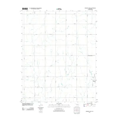
2012 Map of Marshall West
USGS Topo · Published 2012About this map
The town of Marshall anchors the southeastern corner of this Logan County landscape, where the grid of rural roads meets a network of wandering prairie streams. In this 2012 survey, the local genealogy is preserved at the N Marshall Independent Order of Odd Fellows Cem, located just north of the town limits. The terrain is defined by the drainage patterns of Bitter Cr, Wolf Cr, and Skeleton Cr, which flow through a largely agricultural expanse divided by section-line roads like e0550 RD and n2980 RD. The layout of the town itself is clearly delineated, showing the street plan from Main St to Rockwell Ave. This map captures the intersection of organized township surveying and the natural, winding paths of creeks like Horse Cr and Lyon Cr that have shaped the local topography for generations.
Find a feature on this map
34 named features on this map. Tap any name to fly to it.
Don’t see what you’re looking for? This feature index may not catch every label — zoom into the map to look around manually.
Map Details
Editions of this 2012 Marshall West Map
This is the sole edition of this map. No revisions or reprints were ever made.
Other maps of this area

1893 · Lovell
USGS Topo · 1:62,500

1893 · Hennessey
USGS Topo · 1:62,500

1955 · Enid
USGS Topo · 1:250,000

1956 · Garber
USGS Topo · 1:62,500

1956 · Hennessey
USGS Topo · 1:62,500

1956 · Enid
USGS Topo · 1:62,500

1958 · Enid
USGS Topo · 1:250,000

1974 · Marshall West
USGS Topo · 1:24,000

1974 · Marshall East
USGS Topo · 1:24,000
1974 · Bridge Creek
USGS Topo · 1:24,000