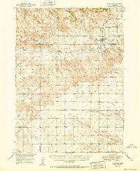
1951 Map of Marsland
USGS Topo · Published 1951About this map
The village of Marsland serves as the primary hub of this High Plains landscape, situated where the Chicago Burlington and Quincy railroad crosses the Niobrara River. This mid-century survey illustrates a dispersed agricultural society defined by its network of rural schoolhouses, including School No 103 and School No 56, alongside a notably marked School No 76 (Abandoned). The topography transitions from the dramatic escarpments of Pine Ridge in the north to the more level reaches of the Snake Creek valley in the south.
Find a feature on this map
21 named features on this map. Tap any name to fly to it.
Don’t see what you’re looking for? This feature index may not catch every label — zoom into the map to look around manually.
Map Details
Editions of this 1951 Marsland Map
3 editions found
Other maps of this area

1899 · Whistle Creek
USGS Topo · 1:125,000

1946 · Nonpareil
USGS Topo · 1:24,000

1946 · Box Butte Reservoir West
USGS Topo · 1:24,000

1948 · Box Butte Reservoir West
USGS Topo · 1:24,000

1948 · Hemingford 4 NW
USGS Topo · 1:24,000

1948 · Nonpareil
USGS Topo · 1:24,000

1951 · Marsland
USGS Topo · 1:62,500

1951 · Kilpatrick Lake
USGS Topo · 1:62,500

1955 · Alliance
USGS Topo · 1:250,000

1957 · Alliance
USGS Topo · 1:250,000