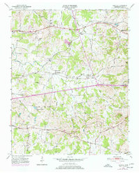
1951 Map of Martha
USGS Topo · Published 1977About this map
The Louisville and Nashville railroad corridor anchors this mid-century portrait of Wilson County, Tennessee, connecting small rural hubs like Martha and Leeville. The landscape is defined by the winding drainages of Cedar Creek and Spencer Creek, where family farms and local institutions developed along the ridges and hollows. The settlement pattern reveals a deeply rooted community infrastructure, evidenced by numerous small educational and religious sites such as Mays Sch, Coronia Sch, and Old Union Ch.
Find a feature on this map
47 named features on this map. Tap any name to fly to it.
Don’t see what you’re looking for? This feature index may not catch every label — zoom into the map to look around manually.
Map Details
Editions of this 1951 Martha Map
4 editions found
Other maps of this area

1903 · Nashville
USGS Topo · 1:125,000

1932 · Hermitage
USGS Topo · 1:62,500

1942 · Gallatin
USGS Topo · 1:100,000

1942 · Lebanon
USGS Topo · 1:100,000

1951 · Lebanon
USGS Topo · 1:24,000

1951 · Martha
USGS Topo · 1:24,000

1952 · Hendersonville
USGS Topo · 1:24,000

1952 · Hermitage
USGS Topo · 1:24,000

1952 · La Vergne
USGS Topo · 1:24,000

1955 · Laguardo
USGS Topo · 1:24,000