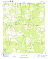
1979 Map of Martin
USGS Topo · Published 1979About this map
The Savannah River Plant dominates the northwestern landscape of this South Carolina survey, marking a significant federal presence along the Savannah River. The terrain is defined by a dense network of tributaries including Lower Three Runs and Three Runs Creek, which flow through the marshy lowlands toward the river boundary with Georgia. Settlement is concentrated along the Seaboard Coast Line railroad, where the communities of Martin and Baldock serve as local hubs. This era shows a rural landscape punctuated by numerous small community anchors, particularly a high density of country churches such as Zion Hill Ch, Gillette Ch, and Mt Hope Ch. To the southeast, the Appleton Lookout Tower stands near the town of Appleton, overseeing the timbered tracts and creeks that characterize the Barnwell and Allendale county borderlands.
Find a feature on this map
34 named features on this map. Tap any name to fly to it.
Don’t see what you’re looking for? This feature index may not catch every label — zoom into the map to look around manually.
Map Details
Editions of this 1979 Martin Map
2 editions found
Other maps of this area

1919 · Allendale
USGS Topo · 1:62,500

1920 · Ellenton
USGS Topo · 1:48,000

1920 · Hilltonia
USGS Topo · 1:62,500

1920 · Peeples
USGS Topo · 1:62,500

1921 · Ellenton
USGS Topo · 1:62,500

1943 · Allendale
USGS Topo · 1:62,500

1943 · Hilltonia
USGS Topo · 1:62,500

1943 · Peeples
USGS Topo · 1:62,500

1943 · Augusta East
USGS Topo · 1:125,000

1943 · Millen
USGS Topo · 1:125,000