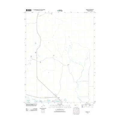
2012 Map of Martin
USGS Topo · Published 2012About this map
McConaughy Lake shoreline dominates the southern edge of this Nebraska Sandhills landscape, where the small settlement of Martin serves as a gateway to the water. The map documents a ranching-heavy interior, characterized by widely spaced family operations including Landis Ranch, Curry Ranch, and McGinley Ranch. These properties are connected by a network of rural routes like Landes Rd and Haythorn Dr, illustrating the vast landholdings required for cattle operations in this region. The northern terrain transitions through Ackley Valley, while the eastern portion of the sheet is defined by the winding course of Whitetail Creek. Recreational infrastructure is evident near the reservoir at Arthur Bay Campground and Martin Bay Campground, marking where the traditional ranching economy meets modern tourism.
Find a feature on this map
16 named features on this map. Tap any name to fly to it.
Don’t see what you’re looking for? This feature index may not catch every label — zoom into the map to look around manually.
Map Details
Editions of this 2012 Martin Map
This is the sole edition of this map. No revisions or reprints were ever made.
Other maps of this area

1897 · Ogallala
USGS Topo · 1:125,000

1900 · Ogallala
USGS Topo · 1:125,000

1954 · North Platte
USGS Topo · 1:250,000

1956 · North Platte
USGS Topo · 1:250,000

1957 · North Platte
USGS Topo · 1:250,000

1967 · North Platte
USGS Topo · 1:250,000

1971 · Martin
USGS Topo · 1:24,000
1971 · Bear Hill
USGS Topo · 1:24,000
1971 · Packard Ranch
USGS Topo · 1:24,000
1971 · Spotted Horse Valley
USGS Topo · 1:24,000