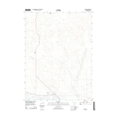
2014 Map of Martin
USGS Topo · Published 2014About this map
Martin sits at the intersection of Ne-61 and Ne-92 in this High Plains landscape, where the northern reaches of McConaughy Lake meet the surrounding ranchland. The geography is defined by a series of north-south drainage patterns and seasonal water bodies, most notably the winding course of Whitetail Cr and the isolated Ackley Lake. This modern survey illustrates the persistent rural character of Keith County, showing how local transport routes like Haythorn Dr navigate the subtle shifts between Ackley Valley and Wildhorse Valley. The map provides a clear record of the area's shoreline and road network during the early 21st century, serving as a reliable reference for those studying the evolution of Nebraska's sandhills and reservoir systems.
Find a feature on this map
10 named features on this map. Tap any name to fly to it.
Don’t see what you’re looking for? This feature index may not catch every label — zoom into the map to look around manually.
Map Details
Editions of this 2014 Martin Map
This is the sole edition of this map. No revisions or reprints were ever made.
Other maps of this area

1897 · Ogallala
USGS Topo · 1:125,000

1900 · Ogallala
USGS Topo · 1:125,000

1954 · North Platte
USGS Topo · 1:250,000

1956 · North Platte
USGS Topo · 1:250,000

1957 · North Platte
USGS Topo · 1:250,000

1967 · North Platte
USGS Topo · 1:250,000

1971 · Martin
USGS Topo · 1:24,000
1971 · Bear Hill
USGS Topo · 1:24,000
1971 · Packard Ranch
USGS Topo · 1:24,000
1971 · Spotted Horse Valley
USGS Topo · 1:24,000