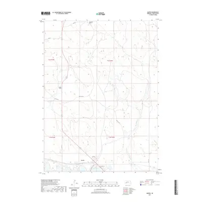
2017 Map of Martin
USGS Topo · Published 2017About this map
Lake McConaughy and its northern shoreline define the southern boundary of this Nebraska landscape, where the waters of No-Name-Bay meet a terrain of sand hills and rolling valleys. The small settlement of Martin sits at the water's edge, serving as a focal point for the surrounding rural road network that includes Old Hwy 61 and Inland Seas Ct. The topography transitions from the lake's basin into the distinct depressions of Ackley Valley and Wildhorse Valley, characterized by intermittent water bodies such as Ackley Lake. This modern survey reveals how local infrastructure, like Broken Axle Rd and Landes Rd, navigates the complex elevations of Keith County. The presence of Whitetail Cr flowing through the eastern sections further illustrates the hydrologic connection between the high plains and the massive reservoir.
Find a feature on this map
20 named features on this map. Tap any name to fly to it.
Don’t see what you’re looking for? This feature index may not catch every label — zoom into the map to look around manually.
Map Details
Editions of this 2017 Martin Map
This is the sole edition of this map. No revisions or reprints were ever made.
Other maps of this area

1897 · Ogallala
USGS Topo · 1:125,000

1900 · Ogallala
USGS Topo · 1:125,000

1954 · North Platte
USGS Topo · 1:250,000

1956 · North Platte
USGS Topo · 1:250,000

1957 · North Platte
USGS Topo · 1:250,000

1967 · North Platte
USGS Topo · 1:250,000

1971 · Martin
USGS Topo · 1:24,000
1971 · Bear Hill
USGS Topo · 1:24,000
1971 · Packard Ranch
USGS Topo · 1:24,000
1971 · Spotted Horse Valley
USGS Topo · 1:24,000