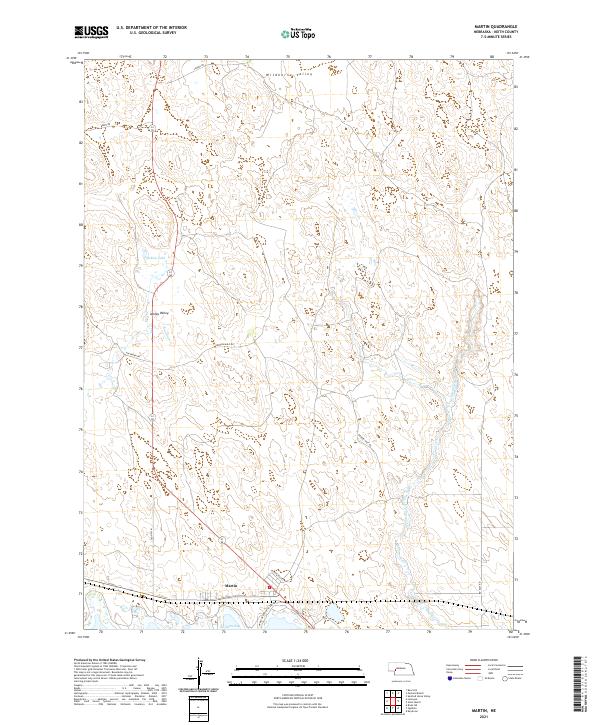
2021 Map of Martin
USGS Topo · Published 2021About this map
Martin sits at the base of this Keith County landscape, where the sandhills of Nebraska meet the water at No-Name-Bay. This 2021 survey illustrates a transition from the agricultural uplands to the recreational and riparian zones along the shoreline. The terrain is defined by distinct depressions and rises such as Wildhorse Valley and Ackley Valley, the latter containing the small, secluded Ackley Lake. A network of rural routes, including the descriptively named Broken Axle Rd and Old Hwy 61, provide access through the varying elevations of the northern townships. The eastern portion of the sheet is drained by the winding course of Whitetail Cr, which cuts through the sandy soil towards the southern basin. The layout of roads like Haythorn Dr and Landes Rd highlights the persistent section-line grid that organizes this ranching and lakefront region.
Find a feature on this map
18 named features on this map. Tap any name to fly to it.
Don’t see what you’re looking for? This feature index may not catch every label — zoom into the map to look around manually.
Map Details
Editions of this 2021 Martin Map
This is the sole edition of this map. No revisions or reprints were ever made.
Other maps of this area

1897 · Ogallala
USGS Topo · 1:125,000

1900 · Ogallala
USGS Topo · 1:125,000

1954 · North Platte
USGS Topo · 1:250,000

1956 · North Platte
USGS Topo · 1:250,000

1957 · North Platte
USGS Topo · 1:250,000

1967 · North Platte
USGS Topo · 1:250,000

1971 · Martin
USGS Topo · 1:24,000
1971 · Bear Hill
USGS Topo · 1:24,000
1971 · Packard Ranch
USGS Topo · 1:24,000
1971 · Spotted Horse Valley
USGS Topo · 1:24,000