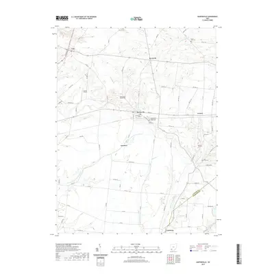
2019 Map of Martinsville
USGS Topo · Published 2019About this map
Lynchburg and Martinsville anchor this 2019 survey of the Clinton and Highland county line, where the agricultural traditions of southwest Ohio meet the headwaters of the Little Miami River system. The landscape is defined by the winding paths of the E Fork Little Miami River and the W Fork E Fork Little Miami River, which carve subtle valleys through a grid of rural township and county roads. Evidence of long-standing community ties is found in the high density of family and fraternal burial grounds, including the Turner Family Cem and the Independent Order of Odd Fellows Cem. These landmarks, along with small nodes like Jonesboro and Morrisville, illustrate a pattern of rural settlement that has remained largely intact. Regional aviation is represented by Barnett Airpark in the northwest, while the Martinsville Road Bridge serves as a key crossing over the E Fork Todd Fork, highlighting the importance of stream crossings in connecting these dispersed farming hamlets.
Find a feature on this map
70 named features on this map. Tap any name to fly to it.
Don’t see what you’re looking for? This feature index may not catch every label — zoom into the map to look around manually.
Map Details
Editions of this 2019 Martinsville Map
This is the sole edition of this map. No revisions or reprints were ever made.
Other maps of this area

1907 · Blanchester
USGS Topo · 1:62,500

1917 · Hillsboro
USGS Topo · 1:62,500

1917 · Sabina
USGS Topo · 1:62,500

1917 · Sardinia
USGS Topo · 1:62,500

1943 · Sabina
USGS Topo · 1:62,500

1944 · Hillsboro
USGS Topo · 1:62,500

1944 · Sardinia
USGS Topo · 1:62,500

1947 · Columbus
USGS Topo · 1:250,000
1960 · Lynchburg
USGS Topo · 1:24,000

1960 · Martinsville
USGS Topo · 1:24,000