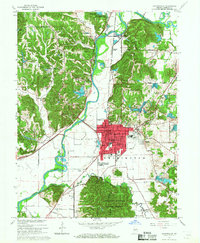
1965 Map of Martinsville
USGS Topo · Published 1967About this map
Martinsville serves as the focal point of this mid-1960s survey, situated along the White River and the corridor of the Pennsylvania Railroad. The town’s social and civic heart is visible through the detailed placement of the Courthouse, City Hall, and several educational facilities like Central Sch and Poston Rd Sch. Beyond the urban core, the landscape transitions into the wooded ridges of the Morgan Monroe State Forest and the Bradford Woods State Reservation, which contains the evocatively named Old Swimmin Hole Lake.
Find a feature on this map
77 named features on this map. Tap any name to fly to it.
Don’t see what you’re looking for? This feature index may not catch every label — zoom into the map to look around manually.
Map Details
Editions of this 1965 Martinsville Map
4 editions found
Other maps of this area

1942 · Franklin
USGS Topo · 1:125,000

1948 · Hindustan
USGS Topo · 1:24,000

1948 · Morgantown
USGS Topo · 1:24,000

1950 · Morgantown
USGS Topo · 1:24,000

1953 · Indianapolis
USGS Topo · 1:250,000

1955 · Hall
USGS Topo · 1:24,000

1955 · Cope
USGS Topo · 1:24,000

1955 · Mooresville West
USGS Topo · 1:24,000

1955 · Martinsville
USGS Topo · 1:24,000

1955 · Mooresville East
USGS Topo · 1:24,000