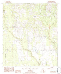
1983 Map of Martinville
USGS Topo · Published 1984About this map
Martinville serves as the central settlement in this portion of St. Tammany Parish, situated among a dense network of tributaries that feed the Tchefuncta River and the Bogue Falaya. The landscape is defined by its many watercourses, including Morgan Branch, Savannah Branch, and Horse Branch, which carve through the territory. This 1980s field survey records a significant density of family and community landmarks, particularly evident in the number of small cemeteries such as Fondason Cem, Wilke Cem, and Burns Cem that dot the countryside.
Find a feature on this map
40 named features on this map. Tap any name to fly to it.
Don’t see what you’re looking for? This feature index may not catch every label — zoom into the map to look around manually.
Map Details
Editions of this 1983 Martinville Map
3 editions found
Other maps of this area

1935 · Covington
USGS Topo · 1:62,500

1935 · Ponchatoula
USGS Topo · 1:62,500

1939 · Ponchatoula
USGS Topo · 1:62,500

1939 · Zona
USGS Topo · 1:31,680

1939 · Covington
USGS Topo · 1:62,500

1942 · Onville
USGS Topo · 1:31,680

1942 · Waldheim
USGS Topo · 1:31,680

1942 · Husser
USGS Topo · 1:31,680

1942 · Robert
USGS Topo · 1:31,680

1950 · Folsom
USGS Topo · 1:31,680