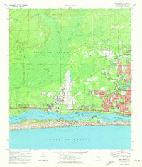
1970 Map of Mary Esther
USGS Topo · Published 1972About this map
Eglin Air Force Base dominates the landscape of the Florida Panhandle during this era of military expansion, centered on the sprawling runways of Aux Field No 9. The coastal settlement of Mary Esther and the growing residential blocks of Fort Walton Beach are shown in transition, with developments like Oakland Heights and Wright pushing northward. The map details the intricate relationship between the land and the water, from the dense East Bay Swamp and the East Bay River to the open expanse of Santa Rosa Sound.
Find a feature on this map
51 named features on this map. Tap any name to fly to it.
Don’t see what you’re looking for? This feature index may not catch every label — zoom into the map to look around manually.
Map Details
Editions of this 1970 Mary Esther Map
4 editions found
Other maps of this area

1921 · Holley
USGS Topo · 1:62,500

1934 · Holt
USGS Topo · 1:48,000

1934 · Harold
USGS Topo · 1:62,500

1936 · Holley
USGS Topo · 1:48,000

1937 · Holt
USGS Topo · 1:62,500

1937 · Harold
USGS Topo · 1:62,500

1938 · Mary Esther
USGS Topo · 1:62,500

1938 · Holley
USGS Topo · 1:62,500

1938 · Harold
USGS Topo · 1:62,500

1956 · Fort Walton Beach
USGS Topo · 1:62,500