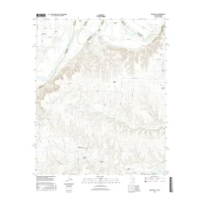
2016 Map of Marysville
USGS Topo · Published 2016About this map
The Red River carves a winding border between Texas and Oklahoma, defining the northern landscape where Cooke Co meets Love Co. This territory is characterized by deep ravines and hollows, including Birchum Hollow and Opossum Hollow, which drain toward the river and Hubert M Moss Lake in the southeast. The settlement of Marysville sits at a crossroads of county roads, while Jimtown occupies the northwestern corner. For family historians, the sheet is exceptionally detailed, noting the specific locations of several rural burial grounds such as Jimtown Cem, Barlow Cem, Weaver Cem, and Bear Head Cem. The terrain's complexity is highlighted by landmarks like Three Mounds and Nubbin Ridge, illustrating the transition from the river bends at Warrens Bend and Tyas Bend to the higher elevations of the surrounding countryside.
Find a feature on this map
50 named features on this map. Tap any name to fly to it.
Don’t see what you’re looking for? This feature index may not catch every label — zoom into the map to look around manually.
Map Details
Editions of this 2016 Marysville Map
This is the sole edition of this map. No revisions or reprints were ever made.
Other maps of this area

1902 · Gainesville
USGS Topo · 1:125,000

1943 · Gainesville
USGS Topo · 1:125,000

1954 · Sherman
USGS Topo · 1:250,000

1958 · Sherman
USGS Topo · 1:250,000

1960 · Gainesville North
USGS Topo · 1:24,000

1961 · Muenster West
USGS Topo · 1:24,000

1961 · Muenster East
USGS Topo · 1:24,000
1968 · Thackerville
USGS Topo · 1:24,000
1968 · Burneyville
USGS Topo · 1:24,000
1968 · Leon North
USGS Topo · 1:24,000