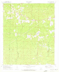
1971 Map of Marysville
USGS Topo · Published 1973About this map
Marysville and the surrounding timberlands of the Columbia and Union county line are defined by a network of petroleum infrastructure and small rural congregations in the early 1970s. The landscape is dominated by the Shuler Oil and Gas Field and the East Shuler Oil and Gas Field, where numerous oil wells and complex pipelines intersect the natural drainage of Beech Creek and Three Creeks. This era shows a community structured around its faith and its dead, with several country churches and burial grounds such as Shady Grove Church, Union Hill Church, and the Babbs Cemetery scattered across the wooded hills. High points in the terrain are utilized for utility and monitoring, including a Lookout Tower in the northeast and a Radio Tower near the Shuler field, while Highway 82 serves as the primary east-west corridor for the region's resource-based economy.
Find a feature on this map
30 named features on this map. Tap any name to fly to it.
Don’t see what you’re looking for? This feature index may not catch every label — zoom into the map to look around manually.
Map Details
Editions of this 1971 Marysville Map
2 editions found
Other maps of this area

1953 · El Dorado
USGS Topo · 1:250,000

1957 · El Dorado
USGS Topo · 1:250,000

1958 · El Dorado
USGS Topo · 1:250,000

1960 · El Dorado
USGS Topo · 1:250,000

1962 · Lisbon
USGS Topo · 1:24,000

1962 · Mt Holly
USGS Topo · 1:24,000

1964 · Louann
USGS Topo · 1:62,500

1966 · Village
USGS Topo · 1:24,000

1966 · Spotville
USGS Topo · 1:24,000
1971 · Wesson
USGS Topo · 1:24,000