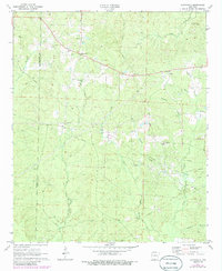
1971 Map of Marysville
USGS Topo · Published 1986About this map
The Shuler Oil and Gas Field and Cairo Oil and Gas Field define the industrial footprint of this southern Arkansas landscape near the Columbia Co Union Co line. Grounded in the early 1970s with mid-1980s updates, the map reveals a countryside where resource extraction and rural community life exist side-by-side. The settlement of Marysville serves as a local hub, supported by a network of spiritual and civic landmarks like Shady Grove Ch and the Marysville Cem.
Find a feature on this map
32 named features on this map. Tap any name to fly to it.
Don’t see what you’re looking for? This feature index may not catch every label — zoom into the map to look around manually.
Map Details
Editions of this 1971 Marysville Map
2 editions found
Other maps of this area

1953 · El Dorado
USGS Topo · 1:250,000

1957 · El Dorado
USGS Topo · 1:250,000

1958 · El Dorado
USGS Topo · 1:250,000

1960 · El Dorado
USGS Topo · 1:250,000

1962 · Lisbon
USGS Topo · 1:24,000

1962 · Mt Holly
USGS Topo · 1:24,000

1964 · Louann
USGS Topo · 1:62,500

1966 · Village
USGS Topo · 1:24,000

1966 · Spotville
USGS Topo · 1:24,000
1971 · Wesson
USGS Topo · 1:24,000