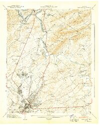
1941 Map of Maryville
USGS Topo · Published 1941About this map
Maryville and its industrial neighbor Alcoa dominate this 1940 landscape, captured just as the Tennessee River was being transformed by the Fort Loudoun Res. The map documents a period of significant regional transition, showing the newly established Knoxville Municipal (McGhee-Tyson) Airport and the sprawling residential developments of Bungalow Town, Plainfield, and Oakhurst.
Find a feature on this map
94 named features on this map. Tap any name to fly to it.
Don’t see what you’re looking for? This feature index may not catch every label — zoom into the map to look around manually.
Map Details
Editions of this 1941 Maryville Map
2 editions found
Other maps of this area

1886 · Knoxville
USGS Topo · 1:125,000

1892 · Knoxville
USGS Topo · 1:125,000

1894 · Knoxville
USGS Topo · 1:125,000

1895 · Loudon
USGS Topo · 1:125,000

1895 · Knoxville
USGS Topo · 1:125,000

1901 · Knoxville
USGS Topo · 1:125,000

1935 · Binfield
USGS Topo · 1:24,000

1935 · Knoxville
USGS Topo · 1:48,000

1935 · Maryville
USGS Topo · 1:24,000

1935 · Wildwood
USGS Topo · 1:24,000