
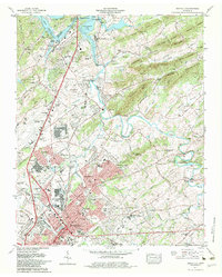
1979 Map of Maryville
USGS Topo · Published 1979About this map
Maryville and the industrial hub of Alcoa sit at the center of this 1979 survey, showcasing a landscape defined by the intersection of the Tennessee River and the expanding Mc Ghee Tyson Airport. The map captures the suburban growth of late-century East Tennessee, with residential developments like Eagleton Village and Meadowbrook filling the gaps between the urban centers and the slopes of the Bays Mountains. Notable cultural institutions are well-documented, including the campus of Maryville College and the Sam Houston School. The presence of several dismantled railroads alongside the active Southern Railway and L & N RR lines illustrates the evolving transportation network as industry shifted away from older rail corridors. Along the Little River, large bends like Horseshoe Bend and islands such as Brakebill Island remain prominent features of the river valley before the terrain rises into ridges like Maxie Ridge and Gravelly Mountain.
Find a feature on this map
129 named features on this map. Tap any name to fly to it.
Don’t see what you’re looking for? This feature index may not catch every label — zoom into the map to look around manually.
Map Details
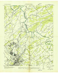
Editions of this 1979 Maryville Map
2 editions found
Other maps of this area

1886 · Knoxville
USGS Topo · 1:125,000

1892 · Knoxville
USGS Topo · 1:125,000

1894 · Knoxville
USGS Topo · 1:125,000

1895 · Loudon
USGS Topo · 1:125,000

1895 · Knoxville
USGS Topo · 1:125,000

1901 · Knoxville
USGS Topo · 1:125,000

1935 · Binfield
USGS Topo · 1:24,000

1935 · Knoxville
USGS Topo · 1:48,000
1935 · Maryville
USGS Topo · 1:24,000
1935 · Wildwood
USGS Topo · 1:24,000