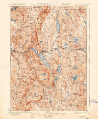
1932 Map of Mascoma
USGS Topo · Published 1937About this map
Lower Shaker Village and Upper Shaker Village sit along the western shores of Mascoma Lake, marking a significant religious and communal landscape in this 1920s survey. The area is defined by a dense network of upland farms and remote school districts, such as Goss Neighborhood Sch and Height of Land Sch, connected by winding roads through the Grafton and Sullivan county hills. The Boston and Maine RR follows the Mascoma River and Indian River, serving industrial and transit points like Pattee Sta and West Canaan. Local commerce and social hubs are evident in unique labels like the Fish Market near Enfield Center, and numerous rural churches including Methodist Hill Ch. This era shows the region before modern highway expansion, where small settlements like Ruddsboro and Lockehaven remained distinct local centers amidst a terrain of granite ledges and numerous ponds like Spectacle Pond and Goose Pond.
Find a feature on this map
137 named features on this map. Tap any name to fly to it.
Don’t see what you’re looking for? This feature index may not catch every label — zoom into the map to look around manually.
Map Details
Editions of this 1932 Mascoma Map
5 editions found

Other maps of this area

1896 · Strafford
USGS Topo · 1:62,500

1902 · Sunapee
USGS Topo · 1:62,500

1905 · Sunapee
USGS Topo · 1:62,500

1906 · Hanover
USGS Topo · 1:62,500

1907 · Sunapee
USGS Topo · 1:62,500

1908 · Hanover
USGS Topo · 1:62,500

1926 · Claremont
USGS Topo · 1:62,500

1927 · Cardigan
USGS Topo · 1:62,500

1927 · Mascoma
USGS Topo · 1:62,500

1928 · Mount Kearsarge
USGS Topo · 1:62,500